


Regional Frost Update on Thursday, March 22, 2018 (2 pm)
go.ncsu.edu/readext?517359
en Español / em Português
El inglés es el idioma de control de esta página. En la medida en que haya algún conflicto entre la traducción al inglés y la traducción, el inglés prevalece.
Al hacer clic en el enlace de traducción se activa un servicio de traducción gratuito para convertir la página al español. Al igual que con cualquier traducción por Internet, la conversión no es sensible al contexto y puede que no traduzca el texto en su significado original. NC State Extension no garantiza la exactitud del texto traducido. Por favor, tenga en cuenta que algunas aplicaciones y/o servicios pueden no funcionar como se espera cuando se traducen.
Português
Inglês é o idioma de controle desta página. Na medida que haja algum conflito entre o texto original em Inglês e a tradução, o Inglês prevalece.
Ao clicar no link de tradução, um serviço gratuito de tradução será ativado para converter a página para o Português. Como em qualquer tradução pela internet, a conversão não é sensivel ao contexto e pode não ocorrer a tradução para o significado orginal. O serviço de Extensão da Carolina do Norte (NC State Extension) não garante a exatidão do texto traduzido. Por favor, observe que algumas funções ou serviços podem não funcionar como esperado após a tradução.
English
English is the controlling language of this page. To the extent there is any conflict between the English text and the translation, English controls.
Clicking on the translation link activates a free translation service to convert the page to Spanish. As with any Internet translation, the conversion is not context-sensitive and may not translate the text to its original meaning. NC State Extension does not guarantee the accuracy of the translated text. Please note that some applications and/or services may not function as expected when translated.
Collapse ▲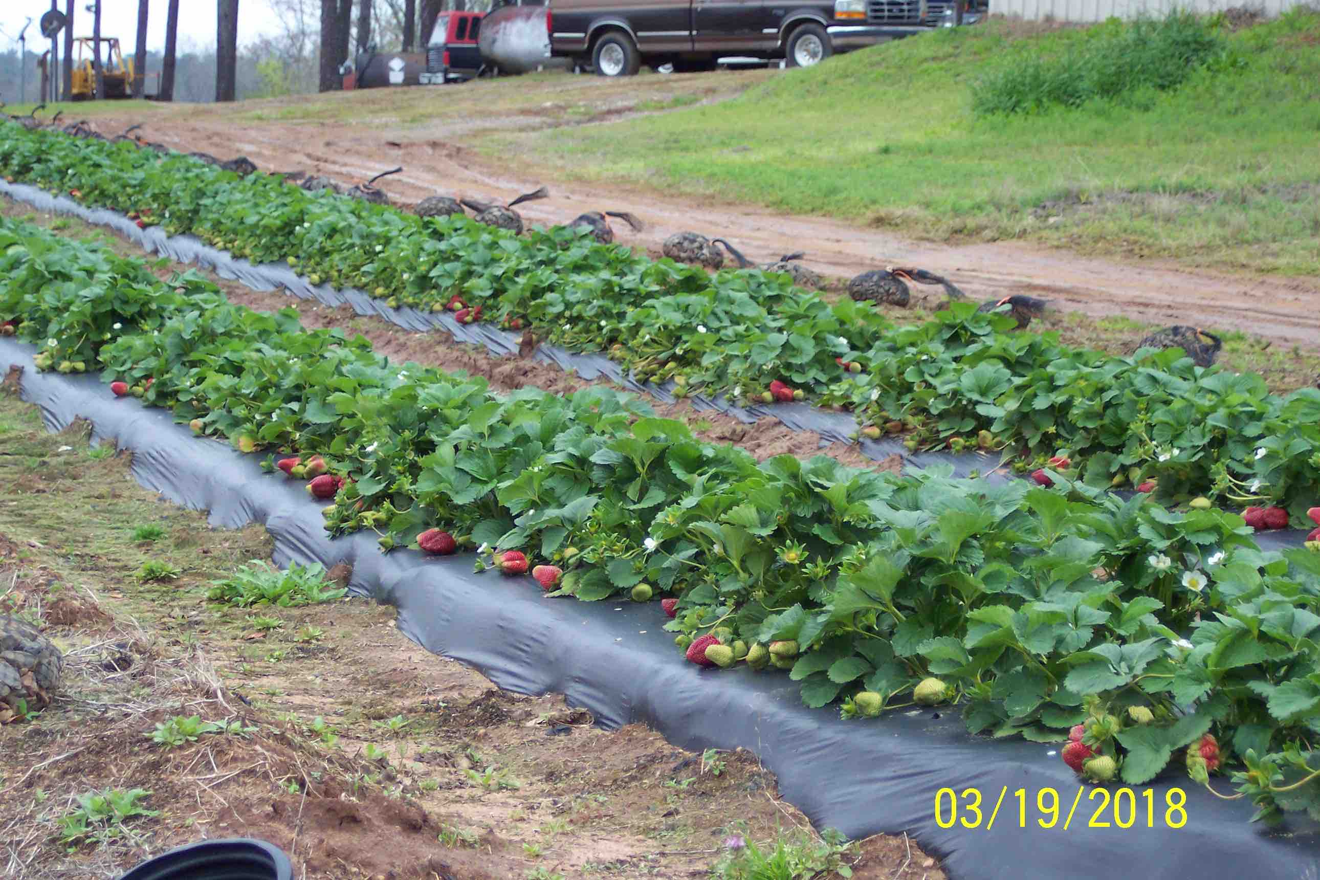
Fig. 1. South Carolina grower, Clyde Gurosik, sent us this photo of his Camarosa crop in N. Augusta on Monday of this week (3/19), and another photo was taken yesterday (3/21) — see the SC section of advisory!
Dear Agents, Agronomists, Growers & Friends,
As was pointed out in this Monday’s “Weather Forecast Outlook for 21 March – 15 April (issued on 3/19/18),” we are now experiencing temperatures well below normal, rains, and we also had snow in many areas! In speaking yesterday afternoon to John Gross in Sanford, NC, I learned that significant rainfall occurred in his area, and row covers were sopping wet going into last night. The last thing you want to have happen is for that wet row cover to “freeze to the plants” during the night — that can cause major damage to flower and fruit parts. And, I gathered this morning in speaking with Whit Jones down in Faison, NC, that row covers at their location did not freeze up (thank goodness). Today, all those wet covers should be able to dry out well in advance of tonight’s cold event (and the next day as well), and that’s a really good thing! With all this nice sunshine today, the covers should build up plenty of heat for going into this evening.
So, let’s do a real quick check on how cold and frosty it may getting in different parts of the region? I am going to begin with Maryland and Virginia, and then tackle the Carolina’s next.
Maryland
I am not sure how far the strawberry crop is advanced in different parts of MD today, but I keep getting these messages that the peak bloom for Cherry Blossoms in DC keeps getting pushed back on account of these very cool temperatures (and snow yesterday). Currently the National Park Service is saying March 27-31. And, it is interesting that these dates would put the cherry blossom peak right on the historical average – I wonder if the strawberry crop in MD will now be coming in at about a “normal time?”
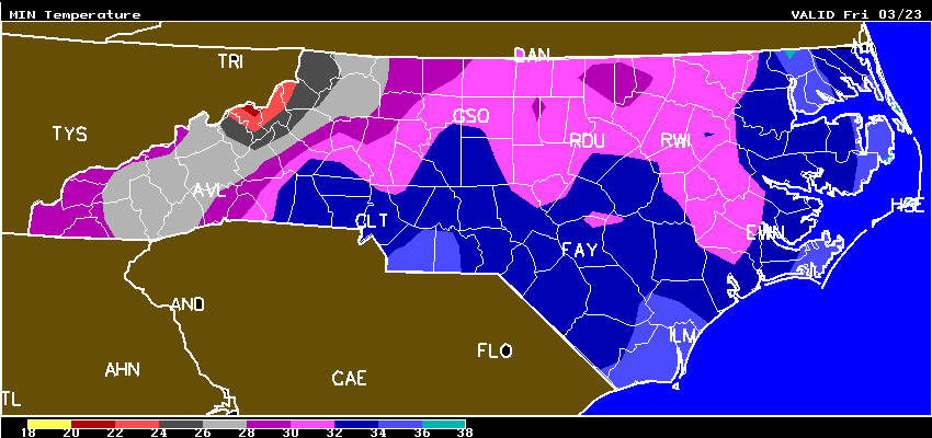
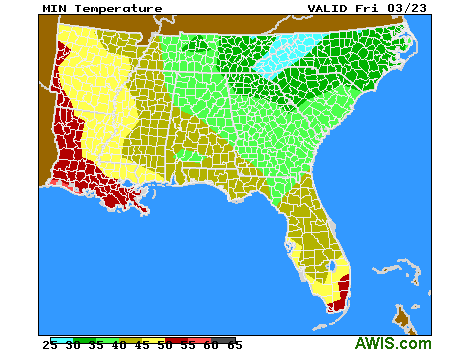
One thing we do know, is that MD and the whole Mid-Atlantic are in for some very cold temperatures tomorrow morning through this weekend.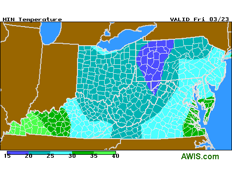 Fig. 1. Mid-Atlantic region minimum temperatures for Friday morning, 3/23
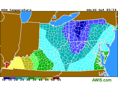 Fig. 2. Mid-Atlantic region minimum temperatures for Sat morning, 3/24
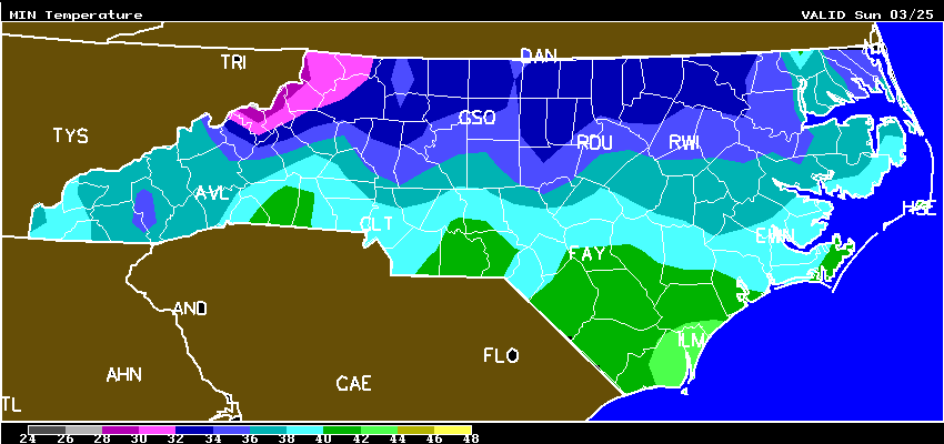
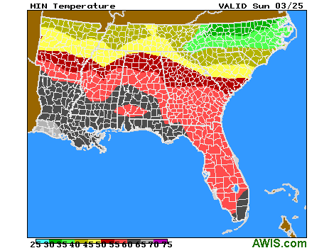
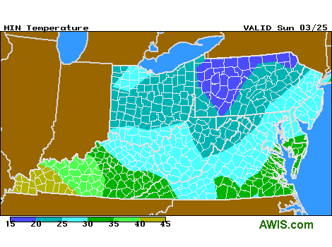 Fig. 3. Mid-Atlantic region minimum temperatures for Sun morning, 3/25
10-DAY DETAILED HOURLY WEATHER FORECASTS (MD)
Virginia – YOU CAN GET A FABULOUS ROUNDUP OF EVERYTHING HAPPENING RIGHT NOW WITH THE VA STRAWBERRY INDUSTRY BY BECOMING A MEMBER OF THE VA STRAWBERRY ASSN (INCLUDES A VERY ACTIVE FACEBOOK GROUP). CONTACT TOM BAKER AND HE CAN GET YOU SIGNED UP! tomandannebaker@cox.net
10-DAY DETAILED HOURLY WEATHER FORECASTS
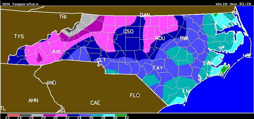
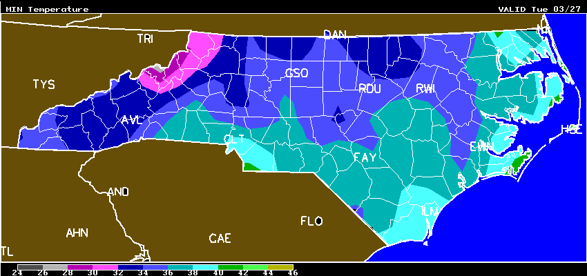
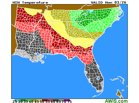
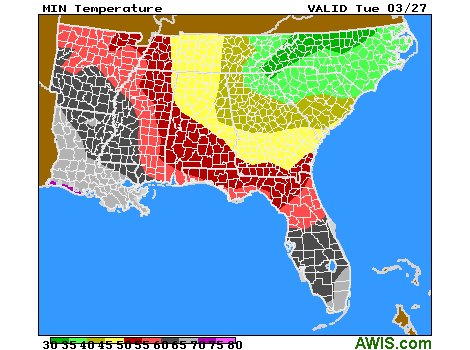
North Carolina – How interesting that last year at this time a number of strawberry operations in Eastern NC were underway with commercial picking by this date! It could be that these same operations will be picking a few berries the first week in April? Or, could it be more like mid-April? One thing you can see from these next 5 AWIS minimum temperature maps, its going to stay quite cool into next week. Everyone should be checking the AWIS 10-Day forecastst for their area very very carefully (next section), and plan accordingly!

Tonights frost/freeze (just for NC)
AWIS Weather Services, Inc. North Carolina Frost/Freeze Forecast
Produced at  505 a.m. CDT on Thu Mar 22 2018

... Forecast for Tonight ... Northeast NC Coast
Currituck/Camden/Pasquotank/Tyrrell Counties

**** NEAR FREEZING COLD LOCATIONS  ****
** PATCHY FROST COLDEST PROTECTED AREAS **

Lowest Temperatures:      33 - 39
Elizabeth_City Min          33
Range Dewpoint Temps:     25 - 34
Range Wetbulb  Temps:     29 - 40
AVG Wind Direction/Speed:  NW  7
AVG Sky Condition:     Partly Cloudy

Extended Forecast: Range of Lowest Min Temperatures in the Above Zones
Min Temps Valid For Morning of Given Date (May NOT include ALL cold pockets)

  03/24/18  03/25/18  03/26/18  03/27/18  03/28/18  03/29/18
  --------  --------  --------  --------  --------  --------
   34 - 40   35 - 41   36 - 42   36 - 43   40 - 47   51 - 57
--------

East Central/SE NC Coast
Carteret/Pamlico Counties

**** FREEZE COLD LOCATIONS  ****
** PATCHY FROST COLDEST PROTECTED AREAS **

Lowest Temperatures:      31 - 35
Morehead_City Min           35
Durations at/below 32:     0 -  2
Range Dewpoint Temps:     25 - 31
Range Wetbulb  Temps:     29 - 39
AVG Wind Direction/Speed:  NW  7
AVG Sky Condition:         Clear

Extended Forecast: Range of Lowest Min Temperatures in the Above Zones
Min Temps Valid For Morning of Given Date (May NOT include ALL cold pockets)

  03/24/18  03/25/18  03/26/18  03/27/18  03/28/18  03/29/18
  --------  --------  --------  --------  --------  --------
   33 - 38   38 - 41   36 - 40   35 - 40   41 - 46   56 - 57
--------

Southeast NC
NWS FORECAST ZONES 87-90,96-101

**** FREEZE COLD LOCATIONS  ****
****  SCATTERED FROST PROTECTED AREAS ****

Lowest Temperatures:      31 - 35
Elizabethtown Min           34
Durations at/below 32:     0 -  2
Range Dewpoint Temps:     22 - 32
Range Wetbulb  Temps:     31 - 40
AVG Wind Direction/Speed:  NW  6
AVG Sky Condition:         Clear

Extended Forecast: Range of Lowest Min Temperatures in the Above Zones
Min Temps Valid For Morning of Given Date (May NOT include ALL cold pockets)

  03/24/18  03/25/18  03/26/18  03/27/18  03/28/18  03/29/18
  --------  --------  --------  --------  --------  --------
   35 - 40   38 - 44   34 - 39   35 - 40   42 - 45   53 - 59
--------

North-Central NC
Franklin County Area

**** FREEZING TEMPERATURES ****
****    PATCHY FROST  ****

Lowest Temperatures:      27 - 34
Louisburg Min               27
Durations at/below 32:     0 -  7
Durations at/below 28:     0 -  2
Range Dewpoint Temps:     16 - 23
Range Wetbulb  Temps:     26 - 36
AVG Wind Direction/Speed:  NW  6     Long Periods of Calm
AVG Sky Condition:         Clear

Extended Forecast: Range of Lowest Min Temperatures in the Above Zones
Min Temps Valid For Morning of Given Date (May NOT include ALL cold pockets)

  03/24/18  03/25/18  03/26/18  03/27/18  03/28/18  03/29/18
  --------  --------  --------  --------  --------  --------
   29 - 37   30 - 38   28 - 37   30 - 37   36 - 43   50 - 55
--------

North/Central NC
Alamance County Area

**** FREEZING TEMPERATURES ****
****    PATCHY FROST  ****

Lowest Temperatures:      29 - 34
Graham_AG Min               31
Durations at/below 32:     0 -  4
Range Dewpoint Temps:     15 - 22
Range Wetbulb  Temps:     27 - 36
AVG Wind Direction/Speed:  NW  6     Long Periods of Calm
AVG Sky Condition:         Clear

Extended Forecast: Range of Lowest Min Temperatures in the Above Zones
Min Temps Valid For Morning of Given Date (May NOT include ALL cold pockets)

  03/24/18  03/25/18  03/26/18  03/27/18  03/28/18  03/29/18
  --------  --------  --------  --------  --------  --------
   32 - 37   33 - 37   30 - 35   32 - 37   38 - 43   51 - 56
--------

South/Central NC
Richmond County Area

**** FREEZE COLD LOCATIONS  ****
** PATCHY FROST PROTECTED AREAS **

Lowest Temperatures:      31 - 34
Ellerbe Min                 34
Durations at/below 32:     0 -  2
Range Dewpoint Temps:     17 - 25
Range Wetbulb  Temps:     30 - 38
AVG Wind Direction/Speed:  NW  6
AVG Sky Condition:         Clear

Extended Forecast: Range of Lowest Min Temperatures in the Above Zones
Min Temps Valid For Morning of Given Date (May NOT include ALL cold pockets)

  03/24/18  03/25/18  03/26/18  03/27/18  03/28/18  03/29/18
  --------  --------  --------  --------  --------  --------
   34 - 39   39 - 41   33 - 36   35 - 37   41 - 44   55 - 57
--------

Interior/EC-SE NC
Wayne County Area

**** FREEZING TEMPERATURES ****
****  SCATTERED FROST PROTECTED AREAS ****

Lowest Temperatures:      30 - 34
Goldsboro_AG Min            32
Durations at/below 32:     0 -  3
Range Dewpoint Temps:     27 - 31
Range Wetbulb  Temps:     33 - 40
AVG Wind Direction/Speed:  NW  6
AVG Sky Condition:         Clear

Extended Forecast: Range of Lowest Min Temperatures in the Above Zones
Min Temps Valid For Morning of Given Date (May NOT include ALL cold pockets)

  03/24/18  03/25/18  03/26/18  03/27/18  03/28/18  03/29/18
  --------  --------  --------  --------  --------  --------
   33 - 37   36 - 40   34 - 38   34 - 41   40 - 46   52 - 57
--------
10-DAY DETAILED HOURLY WEATHER FORECASTS
South Carolina (and regional maps) for Fri – Tue

10-DAY DETAILED HOURLY WEATHER FORECASTS
SC Grower Report (N. Augusta, 3/21/18)
Friends,
Today winds are forecast to gust to 40mph, then drop tonight, along with the temperatures. With Gods’ help we’ve saved them totally, thru 9 frost freezes, so far in March with overhead sprinkler protection. Looks like 2 more nights this week. Already used over 3,000,000 gallons of water and 400 gallons of diesel fuel. Excellent pollination, with very uniform fruit set on all King bloom. Phone is ringing off the hook. Our customers want those true, vine ripened, flavorful strawberries. They say they have had enough of the “CHEAP, HALF GREEN, BEAUTIFUL DISAPPOINTMENTS” shipped in and marketed at all box stores. Opening here on Saturday, 3/24/18 and should be in HIGH COTTON by Easter & Masters week. Please see attached, dated photo taken today. Good luck. Hope this is helpful.
Sincerely,
Clyde Gurosik
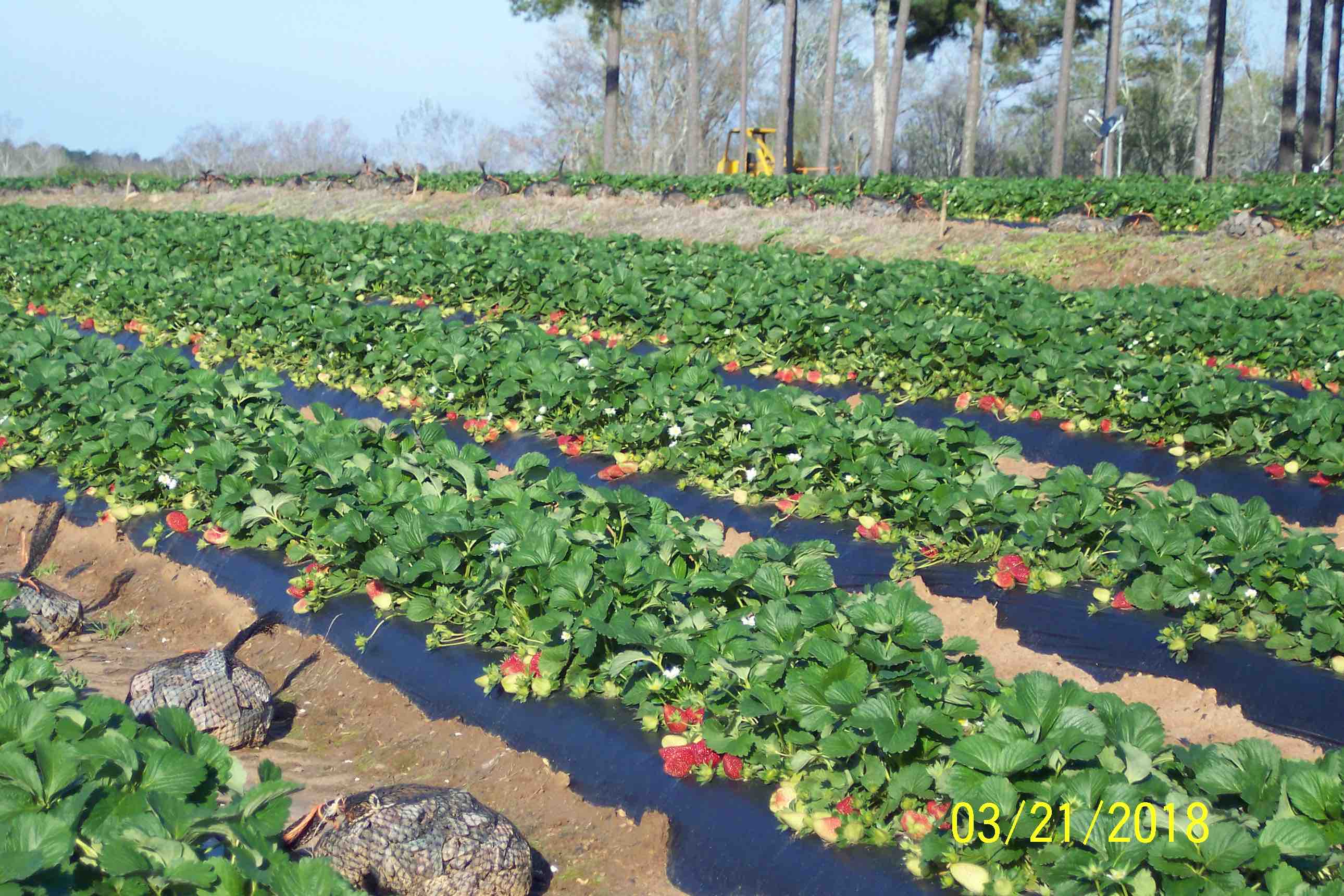 Photo by Clyde Gurosik, 3/21/18 (Camarosa)
Georgia
10-DAY DETAILED HOURLY WEATHER FORECASTS
Kentucky
10-DAY DETAILED HOURLY WEATHER FORECASTS